Showing posts with label Sky and Clouds. Show all posts

Thursday, June 07, 2012

Storm chasing

Retreat

It's been a quiet spring and early summer here in northern Illinois so far, weather wise. Not too many storms brewing up this way. A lot of good my online storm spotter training has done for me, huh? Storm spotter training has taught me the best position from which to view a storm (useful for photography) as well as the worst. Best position also means safest position.

We recently had a small storm system move through late in the day. I followed it on radar via my iPhone as it approached from the west and mapped a route to intercept it (also on the iPhone -- what a great tool. Thanks, Mr. Jobs). My wife and I then drove through the storm and followed it as it headed east. The image above shows the storm retreating over some northern Illinois farmland late in the day. Late afternoon sunlight played across the open fields as menacing clouds snarled overhead.

This image is a combination of two pictures. One was exposed form the sky, the other for the field, then both images were combined on computer.

Wednesday, June 15, 2011

Against the wind

Against the wind

The only thing I like better than photographing people is photographing people doing something they love to do in the environment in which they love to do it. Suzanne was kind enough set aside some time to model for me. More than once. Unpredictable weather canceled more than one scheduled session. We finally wwere able to connect on a chilly spring day to get the picture above. Several times running around the bend. Sun in her face. Wind blowing like crazy. But she loves to run. She loves to help others. By posing for me, she got to do both.

Friday, April 29, 2011

Tempest

Drama in the skies

A look at the skies in northern Illinois while storms and tornadoes battered the southern U.S. Spring is the time when the cold of winter is replaced by the warm of summer. It does not change peacefully, however.

Tempest

Monday, March 21, 2011

What's on the horizon?

On the horizon

You can sit and wait to see what happens or you can go out and meet it.

Monday, October 25, 2010

Zooooom

Zoom

Hi. Remember me? The guy who used to post 20-25 posts a month here? Yeah, that guy.

I was photographing storm clouds rolling in over a corn field out in the open countryside west of Chicago way back in September. Shooting in between passing cars. Finally I thought, why not? I waited for the next car to come by and shot just as it passed. For no other reason than that it might make for an interesting shot.

I pretty much missed autumn as far as getting colorful fall pictures for myself. Most of my weekends were taken up with photography gigs and my weekdays with processing pictures. And it doesn't look like things will ease up any time soon. Not that there's a problem with that. I'm thankful for the work, much of it repeat business and referrals from happy clients. Gotta love that.

Not sure about the fate of this blog. It may wind up going the way of other abandoned blogs. Maybe I can come up with a theme for the winter months and post a series of shots here. Maybe it becomes a showcase for the professional stuff I'm currently doing. Dunno for sure.

I'm now into by-the-seat-of-the-pants video production. Picked up a client that keeps me busy producing short videos. Getting some inquiries for making more videos from here and there.

It's an interesting ride and I'm happy to see where it takes me.

Wednesday, September 08, 2010

Storm is over

Storm is over

Drove through a very heavy thunderstorm on the way home from Wisconsin on Labor Day. Torrential rain, lots of lightning. As my wife and I approached Port Washington, the rains lightened as the tempest headed out over Lake Michigan. We drove to the Port Washington harbor to see what we could see.

What we saw, just for a few moments, was the sun breaking through the clouds and casting rays over the harbor. Some large drops of rain were still falling as I fired off a half dozen shots. The tricky thing about this kind of shot is to make sure you've exposed properly, otherwise, you get blown out areas of pure white, and nothing in post processing can adequately fix those. I'd fire a shot, take a peek at the image's histogram and note with dismay the large areas of pure white, make an adjustment, meter on a bright but not too bright area of the scene and fire again, all the while hoping the magical view stuck around until I got it right.

Number six was the charm. And then the scene disappeared.

In post processing, where I only adjusted levels, I noticed that the dark areas of the image were riddled with small white spots. I thought to myself that I must have done something to mess up the camera's sensor while changing lenses in the rain. Great. I checked other images taken after this scene, and strangely enough, the spots weren't there. What was up?

It was only after I had meticulouly removed each and every white spot that I concluded that the spots were backlit drops of rain. Oh.

Maybe I should have left them in.

Photograph © 2010 James Jordan.

Sunday, August 15, 2010

Along life's road ...

Along the road ...

... it's sometimes stormiest before the calm.

Photograph © 2010 James Jordan.

Thursday, July 29, 2010

Summer

Summer

This is what summer in northern Illinois looks like once you escape the Chicago suburban sprawl, ditch the calendar and put away the e-mail and the cell phone.

I don't do that often enough.

Photograph © 2010 James Jordan.

Monday, July 19, 2010

Rolling in

Storm over the bay

A summer thunderstorm rolls in over Green Bay. Taken in Fish Creek, Door county, Wisconsin.

I've been keeping busy (very busy) processing images from several recent shoots, so posts here have been sporadic. Sorry about that. But there is light at the end of the tunnel, so things should pick up here in the near future.

Thanks for hanging out here and following my occasionally excellent adventures. There is lots more to come.

Photograph © 2010 James Jordan.

Wednesday, July 07, 2010

Balancing Trio

Trio

They've got nice rocks in Door County, Wisconsin. I balanced a few whilst waiting to see what a storm over Green Bay would do. At this point, it had stalled and was breaking apart.

It's been a while since I did any rock balancing. Good to see that I still had the touch. The stormy backdrop was nice.

Oh, and the pressure was on for this piece of ephemeral art. A trolley full of tourists had arrived at the location and were watching me work. Got a couple of oohs and ahhs when I got the center formation balanced.

Thankyouverahmuch. I'm here all week.

Photograph © 2010 James Jordan

Friday, July 02, 2010

This and that

Inflow

As one month ends and another begins, I go through the same thing -- looking through the photographs of the past month and opening a new folder in which to stash photographs yet to be taken.

I keep my pictures organized on my hard drive by month. Subfolders identify specific places and subjects that rose to prominence during that month. It may not be the most user-friendly way of keeping track of things, but one thing it does afford is a quick visual review of my photographic activity of any particular month.

June of 2010 was a busy one. Lots of storms rolled through this month. Today's photograph is of a storm cell that came through northern Illinois in early June. I was standing on the inflow side of the storm. Grass bent toward the cell as air was drawn into the system's convection engine.

The June '10 folder shows lots of places visited, lots of activity. Which is good.

For what it's worth, I'm taking about 1,500-1,700 photographs each month. Not all are kept. June saw about 450 keepers out of nearly 2,ooo clicks of the shutter. That means that about 80 percent of the pictures I take aren't worth seeing. But it doesn't mean that I'm wasting time and energy. Most of those photographs served as guides along the way to capturing the keepers. I am a constant chimper of the LCD screen on my camera. I shoot, look, quickly evaluate and try something else as necessary. Sometimes it's an exposure adjustment. Other times a slight change in position and framing. Or a change of lenses. Sometimes I scrap the idea all together and start an entirely new approach. Each click of the shutter gets me closer to producing the strongest possible image of the subject. Hopefully.

By the way, I had someone ask me if I posted the exposure information of my photographs anywhere and the answer is no ... and yes. I don't specifically post EXIF data, but Flickr does. It draws EXIF data from each picture I upload and posts it in conjunction with the image. If you're ever curious about the exact exposure and camera settings I used to get a particular shot on this blog, just click on the photograph. It will take you to the image's page on Flickr. Scroll down the right hand sidebar until you see "More Properties." Click the link and you'll get every piece of info recorded by the camera.

Hope your skies are sunny and clear as you head into the month of July. But then again, there's something to be said about those storms that occasionally roll through.

Photograph © 2010 James Jordan.

Thursday, July 01, 2010

Sunset over Reefpoint Marina

Sunset over Reefpoint Marina

The day glides to a close in Racine, Wisconsin.

Photograph © 2010 James Jordan.

Thursday, June 24, 2010

The light at the end of the storm

The light at the end of the storm

Let me start with a disclaimer. I don't advocate that anyone go out looking for storms without a lot of advance preparation, a plan and a backup plan. In the case of the line of severe storms that rolled through northern Illinois last evening, I had been keeping tabs on reports from NOAA most of the day and keeping Accuweather's rolling radar map within a couple of mouse clicks. NOAA let me know that developing storms would likely follow a path along the top two tiers of counties in Illinois after afternoon surface heating added the final ingredient necessary for the formation of a mesoscale convective system (MCS) -- fancy weather talk for a really big storm. By 4:00, things were developing rapidly along the Iowa/Illinois border. By 5:00 my wife and I had wolfed down a quick dinner and were in the car.

The plan was to drive west while staying north of the storm, then dropping south to catch the back side where hopefully things would be quite picturesque (and safe). While driving, my wife monitored the radio for reports of storm locations as well as warnings from the National Weather Service that we subscribe to on our cell phone.

After some zigzagging west and south and skirting the edge of the storm, it became clear that the extreme amount of moisture in this system would obscure most of the cloud formations in the storm cells. Bummer. By this time, we were in Elburn, Illinois and a wall of rain was coming in from the west. We decided to punch through it on state route 38. We were treated to an amazing lightning show along the way. We emerged from the rain just east of Dekalb.

Stormy weather

I set up a tripod and set about to capture some lightning. The best way I know to do that is to frame up an area of the sky that is pretty active, set the camera ISO as low as it will go, close the lens aperture all the way down and let the camera pick a (hopefully) long exposure time. I had gotten it down to about a one-second exposure, then just kept clicking away, hoping that lightning would strike while the shutter was open. Out of about a hundred shots, lightning showed up in about a dozen. The image above was the most extensive lightning bolt I was able to capture.

Storm

From there, it was a matter of capturing some of the incidental clouds to the system, then sticking around for the aftermath -- in this case, a sky full of mammatus clouds at sunset.

A few hangers-on

Mammatus sunset

Post-storm sunset

Photographs © 2010 James Jordan.

Wednesday, June 23, 2010

Apocalyptic sunset

Apocalyptic sunset

I finished a photo assignment at a local hospital a couple of nights ago, then met my wife at a nearby shopping mall for a snack and a little walking inside. Afterward, as we headed to our cars in the parking lot, I glanced at the western sky, which until now was under a heavy cloud cover. A small section of the sky appeared to be a boiling mass of pink, similar in appearance to the sky in the movie Independence Day just before the alien ships arrived to destroy the planet.

I joked to my wife that we should hurry home because it appeared that Dekalb just got nuked. We watched the swirling mass grow, then slowly open to reveal pink and gold clouds beyond the portal. Rays of sunlight streamed out of the hole. I shot a few photographs from the parking lot, but having a Home Depot as a foreground wasn't quite cutting it for me. I wrote it off and decided to head home, while my wife drove off to a grocery store to pick up a few items.

Apocalyptic sunset

I shot a few more pictures of the Home Depot apocalypse, then climbed into my car and headed out of the parking lot. My cell phone rang. My wife had called to tell me that the view was spectacular where she was. I turned west and onto the road she had just taken. She was right -- the hole was now closer, larger and shooting rays of light in a gigantic laser light show. My only problem was finding an unobstructed view.

I turned into a subdivision hoping for a clear shot of the sky over some rooftops. No dice. I gave up again and left the subdivision, turning east to head home. I glanced at the rearview mirror then decided to pull over. I got out and got a couple of shots of the roadway and trees beyond. A police car pulled up and asked if everything was OK. I explained I was getting a few shots of the sunset and Mr. Policeman nodded and drove off. I got another dozen or so shots, all hand-held, before the light faded.

Apocalyptic sunset

Photographs © 2010 James Jordan.

Monday, June 21, 2010

Storm story

Severe thunderstorm warning

My wife and I followed the progress of a storm system most of the day last Friday. OK, so I followed it. I just kept my wife updated throughout the day. I think she knew that if things got interesting that I might want to go out and meet the storm as it approached our area. The storm eventually cut a path across six states leaving flooding, downed trees and power outages in its wake.

We received a severe thunderstorm watch alert on my cell phone early in the day. From there I logged onto the NOAA weather site, which provides a daily forecast briefing that meteorologists across the country use as reference in preparing their forecasts. The briefing indicated that a large flying wedge of thunderstorms was sweeping its way across Iowa and heading to Illinois and points east. This storm was a surprise -- it had not previously shown up on any of NOAA's computer models.

A combination of strong convection within the system and high velocity winds aloft meant a pretty good show was on its way. The NOAA site hinted at the possibility of the existence of wind shears, which meant that all the ingredients were in place for the formation of supercells.

I hit Accuweather.com for their rolling radar pictures. Using their time stamps and a trusty old road atlas, I calculated the speed of the storm at about 60mph. Whoa. Nothing to do but keep an eye on the weather reports and wait for our uninvited guest to blow in.

Later that afternoon, when the system approached to within 60 miles of my home, I set out to meet it. My wife came along to monitor the radio and keep me out of trouble. The plan was to photograph the approaching storm, then skedaddle our way back home ahead of it. The whole thing was like one of those algebra story problems -- a severe storm with high winds and heavy rains is heading east at 55 mph. A Ford Escape with a crazy man inside is heading west at 50 mph. Where will the two meet?

Approaching storm

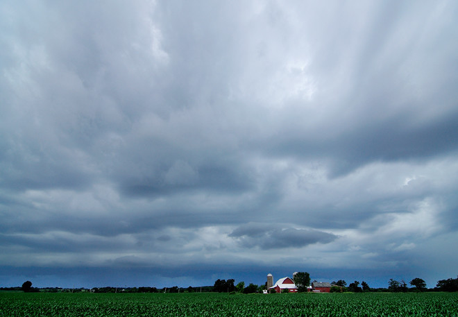
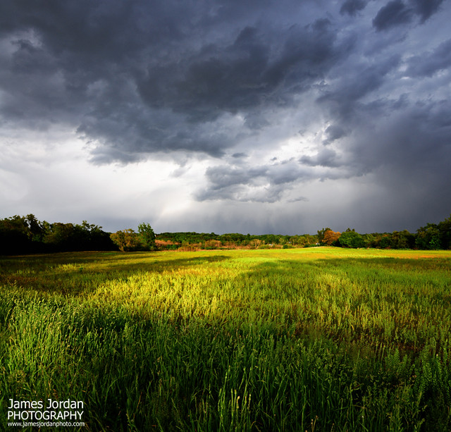
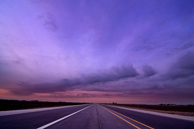
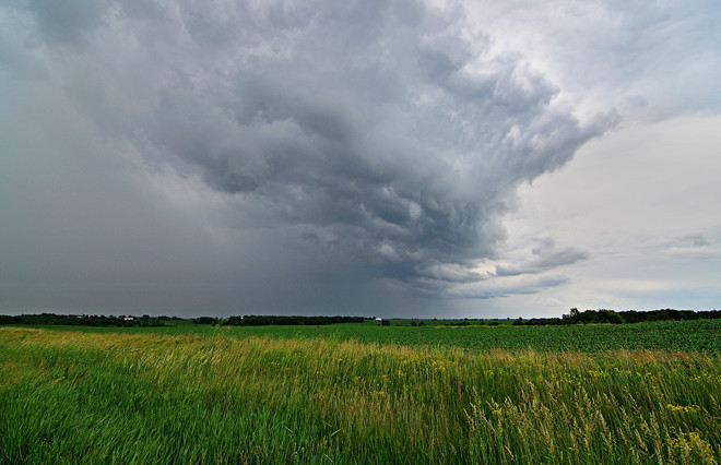
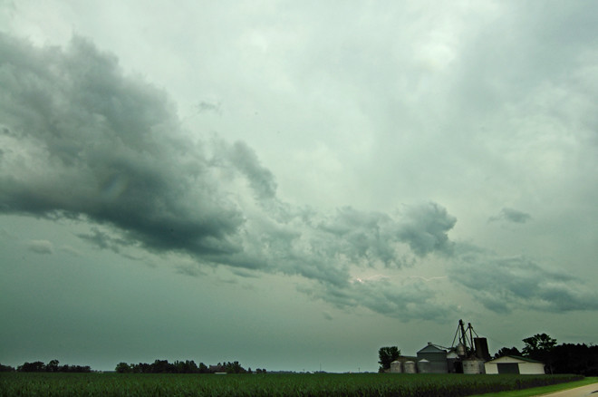
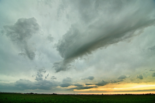
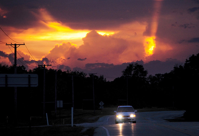
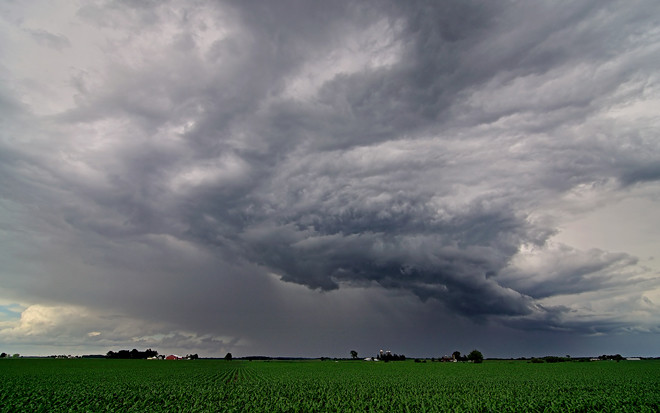
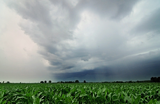
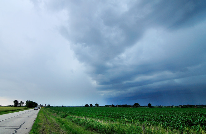
We met just west of Illinois Route 47, a north-south road in western Kane County. As we got closer to the storm, the visual turned from a shapeless mass of dark gray to layers of churning clouds, including a rather impressive shelf cloud riding underneath the stack. Walls of rain hung from the snarling mass along the horizon like sheets on a clothesline. I turned onto a north-south road, located a red barn to frame against the sky, turned the car around so it pointed toward home, then hopped out into a corn field to get some images.

Storm clouds

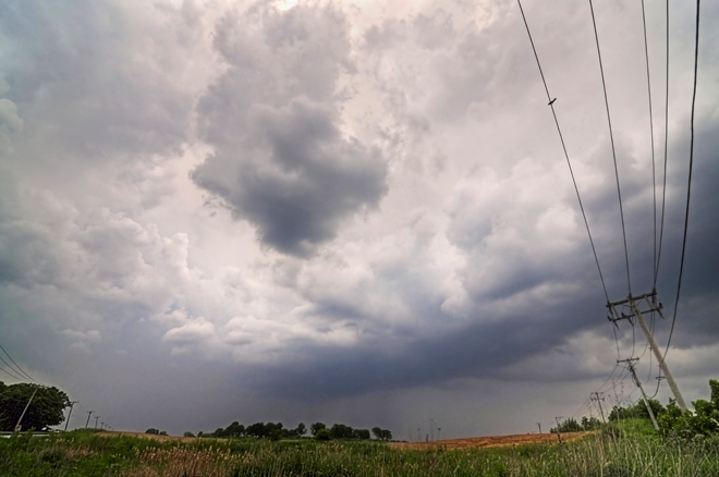
I've shot enough approaching storms to know when enough is enough. I called to my wife, who sat in the car with her window open (I presume to yell to me to get back in at the appropriate time), and let her know that when the lead clouds hit a certain point on the southern horizon, we would make our exit. That would be our cue to get out fast. The clouds didn't quite make it there before I could hear the slow sizzle of very large raindrops striking the leaves of corn on the opposite side of the field. Time to go. I ran back to the car and just got inside as the rain began to fall on us.

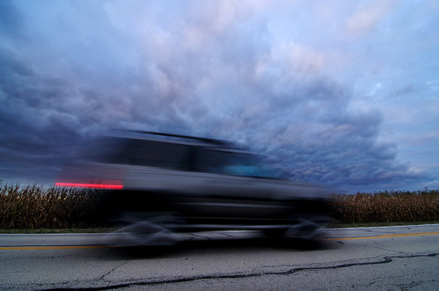
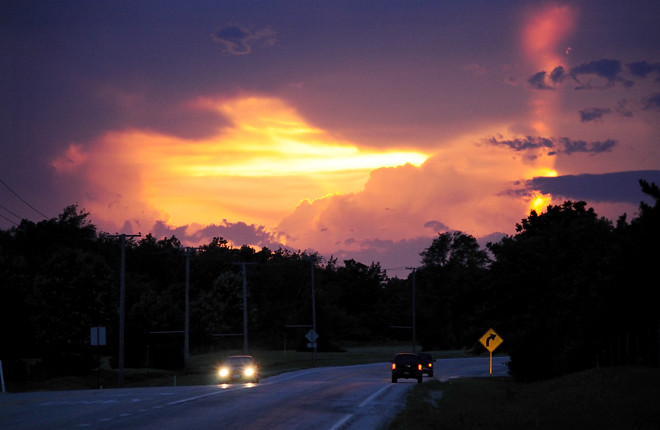
The rain eased, then stopped as we raced eastward, raising my confidence that we could outrun the storm if things worked out for us at a couple of stop lights along the way. At stop light number one, we found ourselves waiting for green behind a farmer on a small tractor hauling a trailer tank full of water. Either he hadn't heard or ignored the weather reports -- there was plenty of water about to be delivered today. Either way, he was about to learn a hard lesson. When the light turned, the tractor pulled out ahead of us at a painfully slow pace. A line of cars the opposite way prevented me from passing the tractor as the rain caught up with us. The tractor hinted at pulling off the road to let us pass, but then swerved back on as the farmer likely rejected the idea of becoming a sitting duck on the side of the road in favor of continuing as a crawling duck. Big raindrops began hitting the roof and windshield as we finally pulled around the slow moving tractor, leaving the farmer behind to deal with his fate.

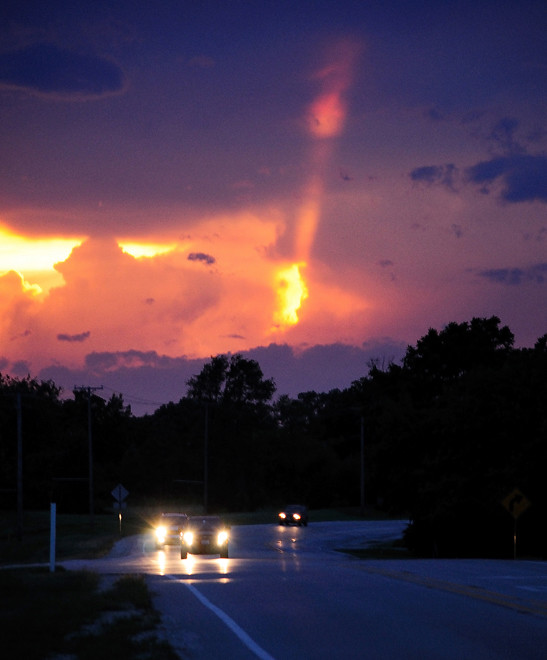
About three miles from home, any hope of outrunning the system disappeared. A section of storm to the south had raced ahead of the mass behind us and closed in on us in a big wet sloppy hug. We slogged though pouring rain and howling winds the rest of the way, dodging fallen trash bins that littered our subdivision like so many casualties in the streets.

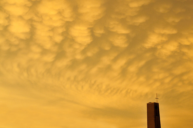
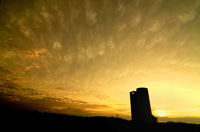
Little damage was sustained in our neck of the woods, although many other areas saw uprooted trees and a few are still waiting for power to return. More storms are in the forecast for the next several days.

I'll keep an eye on them.

Photographs © 2010 James Jordan.

Wednesday, June 09, 2010

Tuesday, June 08, 2010

Against the storm

Against the storm

The lighthouse at Wind Point, north of Racine Wisconsin, set against a backdrop of turbulent skies.

Photograph © 2010 James Jordan.

Monday, June 07, 2010

Storm cell

Storm cell

This past weekend was a turbulent one in the Prairie State. This is the action northeast of Woodstock, Illinois on Sunday afternoon.

My wife and I were returning from Port Washington, Wisconsin and noticed a large storm brewing to the west and north of us. We eventually crossed paths at Lake Geneva. After we had driven through the storm, we kept an eye on it as it drifted eastward toward McHenry. I stopped three times to get photos of the churning clouds.

By the time we arrived home, the skies had cleared and you wouldn't have known that anything dramatic had occured at all.

Photograph © 2010 James Jordan.

Thursday, May 27, 2010

And the windows of heaven were opened

And the heavens were opened

So if you heard a loud gasp at about 3:00 yesterday afternoon, it was me. I had just looked into my viewfinder and saw this thing bearing down on me.

Not that I didn't know there was a storm approaching. I had been out shooting exteriors for a local hospital and took a break because of excessive cloud cover. I went home to monitor the weather and saw some storms approaching. I decided to go out to meet them.

I'm still getting used to a new wide angle lens. It has a field of view that is much wider than my peripheral vision. I saw nasty clouds, but I didn't see all of them appearing to open the bomb bay doors to drop a gusher on me until I peeked through the lens.

After a few shots at a rural crossroads near Elgin (the electric lines at the edges of the picture were going in opposite directions -- that's how wide the view is through that lens), I booked over to the hospital to catch the creeping crud passing over it.

Then I caught my breath.

Photograph © 2010 James Jordan.

Wednesday, May 26, 2010

Time passes slowly

Time stands still

Along the Fox River in West Dundee, Illinois.

Photograph © 2010; James Jordan